The Purchase
On the 20th of May 1841 William Duke purchased land from Philander F. May and his wife, Laura, for $1500.[1] It included the north 100 acres of lot 36 in township two, range two in the Morris Reserve, in the township of Scio. The deed left out an undivided half of the sawmill, mill yard, water privilege and appurtenances which were conveyed to Alexander Black. The wording indicateed Philander held the land free and clear and that Laura agreed to the sale. It’s a simple and typical deed.
That same day, William Duke sold Philander May a parcel of land containing 100 acres of lot 36 in township two, range two of the Morris Reserve, again excluding the undivided half of the sawmill, mill yard, water privilege and appurtenances conveyed to Alexander Black.[2] It was the very same lot he had just purchased, but the price was $500. There was, however, a catch. The document also stated the land would not belong to Philander May unless William failed to pay Philander $167 on 1 June 1842, $166 on 1 June 1843, and $167 on 1 June 1844, plus interest. If William defaulted, then Philander was authorized to sell the land at public auction. Any proceeds received over the amount still owed to him went to William.
While this might seem a little confusing, it is a typical mortgage as they were managed before banks or lending companies became the primary source of loan money for land and homes. In this case, it appears William had the money needed to purchase the 100 acres lacking $500. He became the owner with the first deed and then used the land as collateral for his $500 loan.
William eventually paid his loan off. The clerk who kept the records certified the mortgage was paid by writing, “Satisfied,” in the mortgage index on top of the year of William’s mortgage entry. William’s final payment made the sale of the property back to Philander May null and void, so William retained the title for his property.
The Land-The Morris Reserve
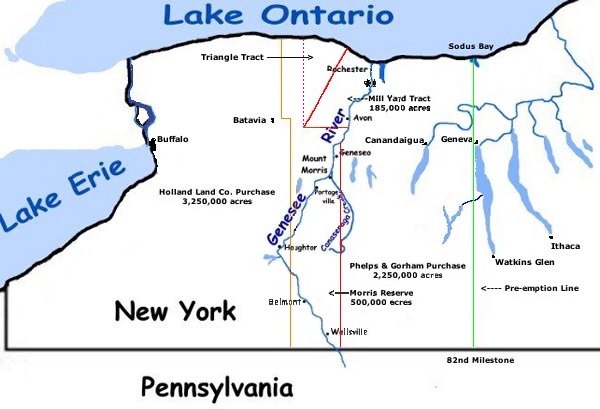
In addition to having an interesting private mortgage deed, the land itself is of note. The Morris Reserve was part of the Phelps and Gorham Purchase, a large tract of land in western New York state that was owned by the Seneca nation.[3] Oliver Phelps and Nathaniel Gorham wanted to purchase all 6 million acres of Seneca land in 1788, but first they had to pay the state of Massachusetts $100,000 as it held the “preemptive right.” The Senecas agreed to part with 2.25 million acres for $5000 with a perpetual annuity of $500 per year.
Within a year of completing the purchase agreement, monetary values rose so high that Phelps and Gorham could not make their payments.[4] In 1791, Robert Morris (1734-1806) of Philadelphia (financier, Founding Father, and later US senator) stepped in to make the remaining payments to Massachusetts and to buy the 1 million acres of Seneca land for which payment was still due. Phelps and Gorham then sold most of the 1.25 million acres they had purchased to Morris as well. The richest man in America at that time bought a big chunk of New York land.
The first thing Morris did was commission a new survey.[5] The old one was inaccurate due to mistakes, a lack of geographical knowledge, primitive surveying instruments, and possible fraud by the early surveyors. Even before the survey was completed, some land was sold off to London investors and to the Holland Land Company.[6] Morris reserved 500,000 acres for himself, which is how the land William Duke purchased got its designation, the Morris Reserve. [7]
The beginning of Allegany County
In 1796, Morris needed funds. John Barker Church created a mortgage for Morris on 100,000 acres of the Morris Reserve in what would later become Genesee County and its daughter county, Allegany.[8] Collateral for the loan was the Morris Reserve. When Morris failed to pay that debt, Church foreclosed. His son, Philip Schuyler Church, acquired the land in May of 1800 from his father and began settlement by founding the village of Angelica in what would become Allegany County.
The descent of William’s land
Lot 36 can be traced back to:
Philander May (purchased from Ellis May & wife in 1837)
Ellis May (purchased from Philip Church & wife in 1833)
Philip Church (received from John Barker Church by 1810)
The Allegany County deed index does not include individual listings of the earliest lands that Philip got from his father. Finding Lot 36 in Township 2, Range 2 would be a time-consuming, page-by-page search. What can be stated is that William Duke became the sixth person to own the Allegany County property when he purchased it in 1841.
Most of western New York was owned and surveyed by large landowners and land companies using the township system.[9] The Morris Reserve was acquired first from the Seneca then parceled out to a variety of private purchasers. Owners like Robert Morris and John Baker Church could decide the size and shape of lots within the Reserve, which they marked out using the township system with its straight lines and town and range descriptions with numbers. This differs from other areas of New York and northeastern states where the towns and colonies (later states) surveyed and allocated lots, using landmark (tree to post to rock) descriptions. Numbering within the Reserve was mostly done by original proprietors so is not uniform and intuitive, therefore researchers need to consult plat maps and other sources to determine exactly where the land was located.
[1] Allegany County, New York, Mortgage Book N, page 43, 20 May 1841; imaged, FamilySearch (www.familysearch.org : accessed 18 March 2014), image group number (IGN) 7136141 > image 31 of 667.
[2] Allegany County, New York, Deed Book 13, page 2, 20 May 1841; imaged, FamilySearch (www.familysearch.org : accessed 18 March 2014), image group number (IGN) 7136025 > image 329 of 641.
[3] Wikipedia (www.wikipedia.org : accessed 29 March 2024), “Phelps and Gorham Purchase,” revised 21:10, 3 February 2024.
[4] Wikipedia, “Phelps and Gorham Purchase,” revised 21:10, 3 February 2024.
[5] Wikipedia, “Phelps and Gorham Purchase,” revised 21:10, 3 February 2024.
[6] The land purchased by the London investors became known as the Pultney Purcases or Genessee Tract. The Holland Land Company was a syndicate of Dutch bankers.
[7] Wikipedia, “Phelps and Gorham Purchase,” (https://commons.wikimedia.org/w/index.php?curid=1218794), revised 21:10 3 February 2024. Note, William’s land purchase in Scio is very close to Wellsville.
[8] Wikipedia, “Phelps and Gorham Purchase,” revised 21:10, 3 February 2024.
[9] E. Wade Hone, Land and Property Research in the United States (Salt Lake City, Utah: Ancestry Incorporated, 1997), 64.